From the marble fragments of the Forma Urbis to Nolli's detailed Map: the historical representation of the city of Rome
The history of the oldest maps of Rome and the difficult placement of the Forma Urbis
15 June 2024
Rome Travel GuideThe exhibition choice: the wall on the ground and the Nolli Map
Discover the rich history of Forma Urbis, the monumental marble plan representing ancient Rome, in a journey through the centuries that marked its discovery, preservation and rediscovery.
Its story begins as far back as 1562, when fragments of the plan were found and brought to Palazzo Farnese, in a golden age of studies on ancient Rome. The enthusiasm generated by this discovery gave rise to a fruitful season of exploration of the plan, evidenced by the first drawings of the fragments preserved in a codex in the Vatican Library. These drawings, reproduced to scale, not only helped to integrate the missing parts of many plates, but also represented the only evidence of lost fragments. During his long stay at Palazzo Farnese, some fragments of the plan were used as construction material for work in the Garden on the Tiber. Fortunately, what remained was saved from oblivion by the publication of antiquarian Giovan Pietro Bellori in 1673, although his drawings were still inaccurate. Despite the imperfections, Bellori's publication rekindled interest in the Forma Urbis, which eventually reached the Capitoline Museum in 1742, thanks to the support of Benedict XIV. There, the fragments were mounted on panels along the staircase of the Palazzo Nuovo, in an exhibition that helped reinvigorate interest in the architecture depicted in the plan.
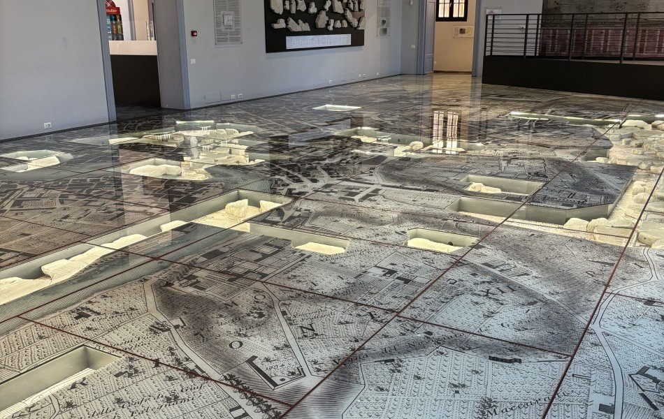
Later, in 1903, the plan was displayed in the Roman Garden at the Capitol. This arrangement marked the first attempt to recompose the Forma Urbis organically, although the arrangement of the fragments did not allow a complete and detailed view of the plan. With the decision to radically transform the viewpoint, the wall becomes the ground: the grid of marble slabs, originally arranged vertically, is now reflected in the texture of the glass plates that form the floor. In this grid, all the marble fragments are carefully inserted into the fabric of the city.
Giovanni Battista Nolli's renowned plan of Rome was chosen as the ideal reference point to connect ancient and modern Rome. In fact, the ancient survey used to create the marble plan is comparable in its precision and technical rigor only to the first major modern survey of the city, carried out more than a millennium and a half later by engineer and architect Giovanni Battista Nolli. His Nuova Pianta di Roma, published in 1748, is considered a masterpiece of all-time cartography. The result of a long process of large-scale surveys, the map depicts in detail the buildings, churches, palaces, fountains, obelisks, gardens and vineyards. The vineyards and “uninhabited” areas of Nolli's city show how much more like the ancient city Rome was than the contemporary one. The Aurelian walls do not even outline the built-up area, and the vineyards with the emerging ruins give us an image of the lost city and at the same time clearly reveal the imprint of the ancient metropolis.
The panorama of the city in Nolli's time was thus that of an almost empty Rome, a landscape that oscillated between rural and urban. This scenario is in stark contrast to what we would find in the time of the Severans, in the early third century CE: a city densely populated with insulae, patrician mansions and monuments, perhaps even over-urbanized, the grandeur of which prompted the emperor to request a cartographic representation of it.
Mapping Ancient Rome
Giambattista Nolli 1748 succeeded in a great feat, which is a milestone in the art and science of cartography since modern surveys and sophisticated satellite imagery have confirmed the absolute accuracy of the map down to the smallest margin of error: by far the most accurate representation of the city produced until then. This map fills a need that arose during the eighteenth century when maps were in support of the wealthy viveur who adhered to the Grand Tour fashion of the great European capitals.
However, we can say that maps of ancient Rome began to be increasingly used as early as the sixteenth century when numerous of them were already found probably to satisfy that need to entice and direct pilgrims on their journeys to the Holy City. The main feature of the sixteenth-century plans is the increasing adherence to reality, that is, to the territory, such that they are sometimes used for security and military use. In these maps one can generally see a really tiny city, compared not only to its present size but also to that of imperial Rome.
It is this type of map that inspired Giovan Battista Nolli and in particular the Map of Leonardo Bufalini produced in 1551, considered “the first correct map of the city since Forma Urbis,” since all previous images of the city were views. Bufalini's map is the first printed map of Rome and is a milestone in the history of city maps. The earliest source for Bufalini's Pianta is Bartolomeo Marliano's Pianta di Roma antica, published in Rome in 1544 and which has the same orientation and accuracy in detail as Bufalini's. Although rare, Bufalini's Pianta had a great influence on later plans of Rome, which took it up to varying degrees in its essential contents.
As we have said, Nolli himself is inspired by Bufalini's map, but he reorients it toward magnetic north, which testifies to his reliance on surveys made with a compass, and represents both covered public spaces and open civic spaces.
Indeed, it is from Nolli's New Map of Rome that we come close to perfection and people begin to use maps even to orient themselves within the city since his map is so well done that we could still use it today to explore the city. compared not only to its current size, but also to that of imperial Rome.
You may also be interested ...
Guided Audio Tour Colosseum with Roman Forum and Palatine Hill
Private tour
Discover the secrets of the Colosseum and Ancient Rome independently with our immersive Colosseum guided audio tour, rich in image and content
starting from: € 51 € 42

Domus Aurea Tour with VR Experience: The one-of-a-kind Architecture of Ancient Rome
Small group tours
![]()
![]()
![]()
![]()
![]() (15)
(15)
Immerse yourself in the vast frescoed halls of Nero's Domus Aurea. You won't believe your eyes! Uncover its secrets!
starting from: € 85 € 61