New Forma Urbis Museum in Rome: the display of the giant marble map from the 3rd century
Capture the essence of the Eternal City through centuries of cartographic changes and discover the link between past and present in its extraordinary topography
26 April 2024
Rome Travel GuideThe new Museum of the Forma Urbis with the marble map of Imperial Rome
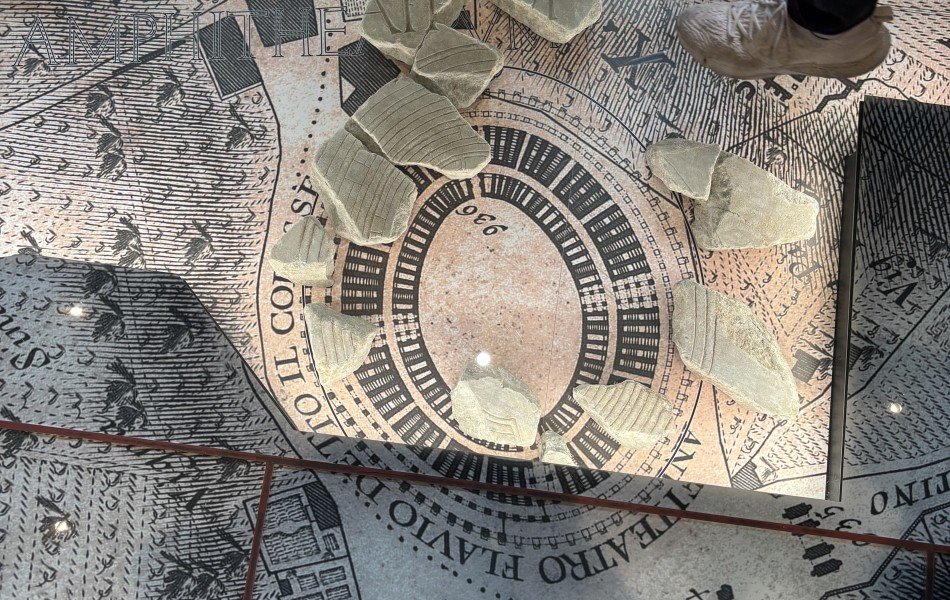
In the heart of Rome, next to the Colosseum, stands a new cultural gem destined to enchant and inspire history and archaeology enthusiasts: the Museo della Forma Urbis. In this fascinating museum located on the Caelian Hill, visitors can plunge into the depths of the past, exploring the Eternal City through the ancient marble map known as "Forma Urbis." But this is not only a museum dedicated to ancient Rome; it is also a starting point for understanding the modern city through the lens of history and topography.
In fact, the map made by Giovanni Battista Nolli in the 18th century serves as the basis for the floor on which the marble fragments of the Forma Urbis rest. One can walk on them, easily comparing the map of Rome, reconstructed by Nolli, with the certain fragments of the Forma Urbis floor plan. The exhibit is well curated, offering visitors a unique perspective on the history and evolution of Rome, from its ancient origins to the present day. If you are interested in discovering this magnificent Museum, come with us on the tour of Ancient Rome through Forma Urbis, an unmissable experience you cannot miss.
The Forma Urbis Severiana: the incredible plan of Rome commissioned by Septimius Severus
Before exploring in detail the history and importance of the Forma Urbis, it is essential to understand what it represents and how it fits into the cultural and historical landscape of ancient Rome. The Forma Urbis is one of the rarest documents to have come down to us from antiquity, providing a unique view of the urban landscape of imperial Rome. It consisted of about 150 rectangular marble slabs, of varying sizes, arranged in eleven rows to form, in its entirety, an area of about 18x13m where about 13,550,000 m2 of the city was represented.
The slabs were the covering of an exterior wall of one of the halls of the imposing Temple of Peace. The fact that the immediately adjacent room was reused in the 6th century for the Basilica of Saints Cosmas and Damian allowed for the preservation of the wall to which they were affixed. On the original wall on which the Forma was to be affixed, the holes used for the brackets to attach the plan are still visible. The Forma Urbis was commissioned by Emperor Septimius Severus and can be dated between 203 and 211 AD. In fact, the plan would be later than 203 because on it it is possible to recognize the Septimonium, the monumental façade of a nymphaeum commissioned by the emperor and built on that date, and earlier than 211, the year of the death of Septimius Severus, who is mentioned as reigning together with his eldest son Caracalla.
In fact, an inscription engraved on a group of fragments reads: SEVERI ET [AN]TONINI AV[GG] NN [...], or "of Severus and Antoninus, our augusts." The absence of the name of Septimius Severus' other son Geta, who assumed the throne in 209, suggests an earlier date and may be an indication of foul play. Geta in fact was made emperor upon the death of Septimius Severus along with his brother Caracalla. However, in 211 Geta was accused of having wanted to seize power and kill Caracalla and for this he was declared an enemy of the state, killed by a group of centurions and sentenced to damnatio memoriae, the erasure of his memory.
The plan is oriented, unlike modern usage, with southeast up not north as is usual for us. Probably today's Monte Cavo, the highest peak of the Alban Hills, today's Roman castles area, was used to make the topographical surveys of the plan. On the plan there were represented, through a multitude of thin engravings successively painted red, all the buildings of Rome, public or otherwise, depicted mainly at ground level with graphic conventions generally of immediate comprehension. With an average scale of about 1:240, the Forma Urbis allows an extremely detailed plan representation of Ancient Rome, enabling us to distinguish even individual rooms within buildings. The dimensions of some monuments, however, were shown at a larger scale, probably so that they would be clearly visible even from a distance and serve a primarily orientational and celebratory function.
The enigmatic function of a giant map
What has been said so far leads us to the big question behind the making of this ancient map: what was its function? What the purpose of the immense map was is still debated to this day. The idea of a relationship with the library of the Forum of Peace prevails, and the presence of an administrative office connected with the Urban Prefecture, the institution that precisely with a reform of Septimius Severus saw the terms of its sphere of influence defined also territorially. That the plan itself had a practical function is unlikely, however, considering its location, difficult legibility and general lack of detail.
But how could the details of a depiction that stretched more than 18 meters high, that is, like a four-story building, be seen? Not only that, the ancient observer who found himself viewing the map from below first had before his eyes a 4-meter-high band of colored marbles, from which the map then departed. Thus it must have been extremely difficult to read the captions and impossible to understand the details of the plans, especially of the higher parts. Thus, for example, an imposing monument such as the Septizodium, which marked the entrance into Severan Rome placed on the map in the fourth-to-last row of slabs at the top, must have been barely traceable on the map. Prevailing today is the idea that the marble plan rendered a general view of the city, so the observer would be able to appreciate its grandeur and identify, partly through the use of color, the outlines of the great monuments, such as the Circus Maximus and the Colosseum.
In short, a propaganda function, a celebration of power and technical knowledge rather than a practical function.
You may also be interested ...
Guided Audio Tour Colosseum with Roman Forum and Palatine Hill
Private tour
Discover the secrets of the Colosseum and Ancient Rome independently with our immersive audio guide, rich in image and content
starting from: € 41 € 31

Domus Aurea Tour with VR Experience: The one-of-a-kind Architecture of Ancient Rome
Small group tours
![]()
![]()
![]()
![]()
![]() (15)
(15)
Immerse yourself in the vast frescoed halls of Nero's Domus Aurea. You won't believe your eyes! Uncover its secrets!
starting from: € 85 € 61